|
GR®59
From Vosges to Jura
From Ballon d'Alsace (Vosges) to Culoz (Ain)
|

|
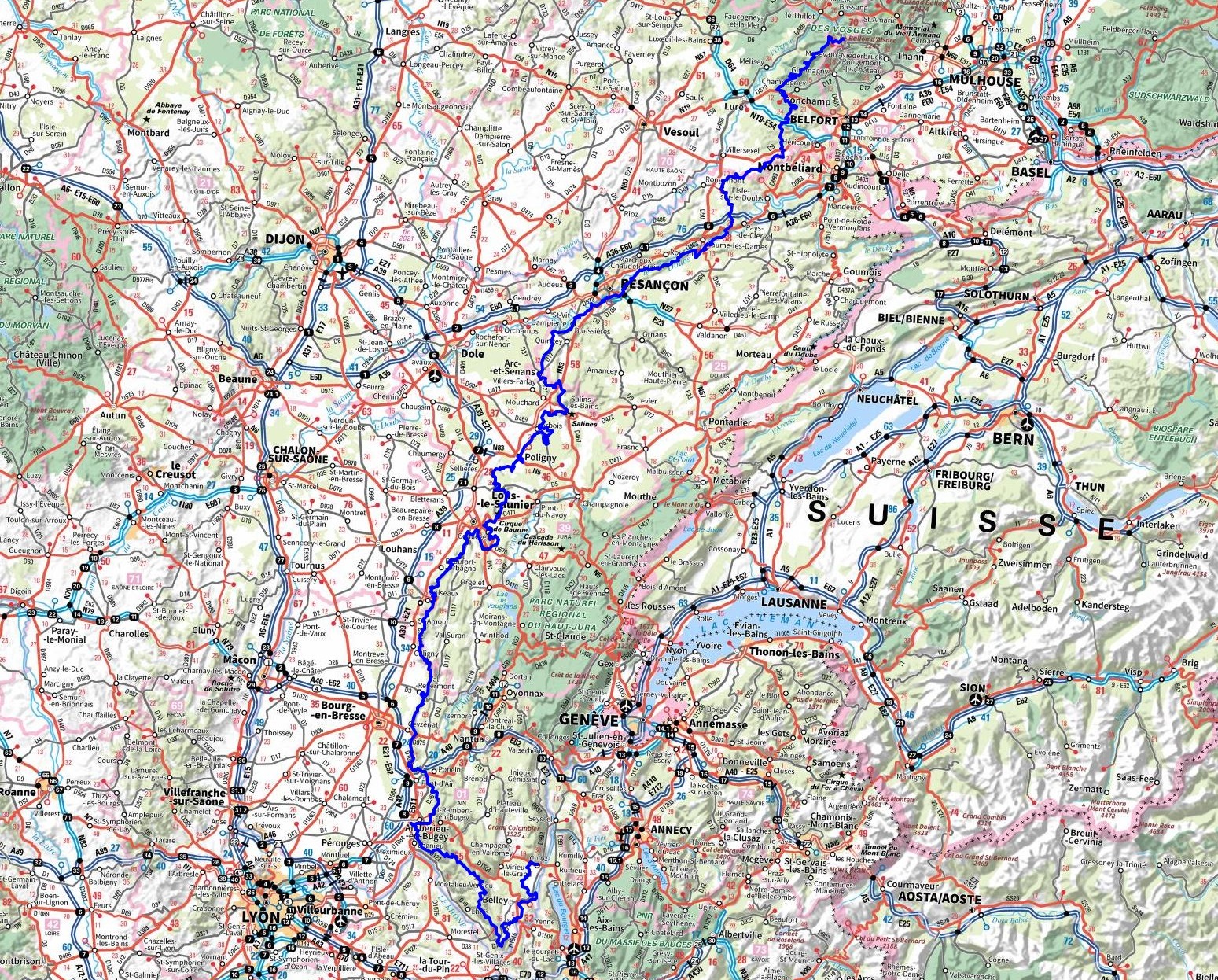
The GR®59 trail begins at Ballon d’Alsace, standing at an altitude of 1,247 meters. It traverses the regions of Haute-Saône and Doubs, where picturesque villages and historic castles adorn the path. The trail then continues into the Jura, a region celebrated for its stunning natural landscapes, including waterfalls and caves. Upon entering Savoie, the GR®59 offers breathtaking views of the Alps. Finally, the path leads to Ain, where the rugged mountains gradually transition into softer, rolling hills. Hikers will conclude their journey in Culoz, a charming village nestled at the foot of the Grand Colombier.

Google Maps - Google Earth


© GPX Private use only |
Distance: 605km, Elevation maximum: 1246m, Elevation minimum: 218m, Elevation gain uphill: 16380m
IGN Maps: Baume-les-Dames (3422E). Baume-les-Dames Vallee du Doubs (3423ET). Ballon d'Alsace PNR des
Ballons des Vosges (3520ET). Melisey (3520O). Lure (3521O). Bussang la Bresse Ballon d'Alsace PNR des Ballons des Vosges (3619OT). Besançon foret de Chailluz (3323ET). Marnay (3323O). Arc-en-Senans Quingey Vallees de la Loue
et du Lison (3324ET). Arbois Salins-les-Bains foret Domaniale de la Joux (3325OT). Poligny (3225E). Lons-le-Saunier Poligny Reculee de Baume (3226ET). Lons-le-Saunier (3226O).
St-Amour Arinthod Orgelet (3227OT). St-Amour (3128E). Bourg-en-Bresse Est (3129E). Amberieu-en-Bugey (3130E). Lons-le-Saunier
Poligny Reculee de Baume (3226ET). Lons-le-Saunier (3226O). Oyonnax Gorges de l'Ain (3228OT). Nantua Hauteville-Lompnes Nord Bugey (3230OT). Amberieu-en-Bugey
Champagne-en-Valromey massif du Bugey (3231OT).

Registration
Accommodation or business owner on or near a GR®, you can appear on GR-INFOS
For your registration, you can send me by email (papadimitriou4@gmail.com): your address and phone number, your website (Facebook page), a brief description with 5 beautiful photos of your establishment.
Registration price : 100€/5 years per GR® or GRP®. Renewable. |
GR®59 From Vosges to Jura
From Ballon d'Alsace (Vosges) to Silley-Blefond (Doubs)
From Silley-Blefond (Doubs) to Mesnay (Jura)
From Mesnay (Jura) to Val-Revermont (Ain)
From Val-Revermont (Ain) to Culoz (Ain)
Nearby paths:
Around Pays de Courbet (Doubs)
Around Revermont (Ain, Jura)
Around Ain Valley in Pays de Cerdon (Ain)
Crossing Dombes (Rhone-Ain)
Jura escape (Jura)
Around Bresse Comtoise (Jura)
Around Valromey Balcony (Ain)
GR®5 From Luxembourg to Mediterranean
GR®7 From Vosges to Pyrenees
GR®9 From Jura to Mediterranean
GR®65 Camino de Santiago Via Gebennensis
GR®145 Via Francigena
GR®509 Great crossing of Jura
GR®531 Across Vosges Massif
GR®532 Vosges crest and high valleys
GR®533 Vosges crests and lakes
GR®559 From Lons-le-Saunier to Rousses (Jura)
 It is advisable to follow the beacons all along your hike and to bring you the FFRandonnee topo-guide. You
will also find information on MonGR.fr.
GR®, PR®, GRP®, and the corresponding signs of markings (white / red, yellow and yellow / red) are trademarks of the French
Federation of Hiking. They may not be reproduced without permission. The French Federation of Hiking, state-approved, includes organizations that create and maintain hiking routes on GR®, PR® and
GRP®. It publishes guides these topo hiking routes.
With your donations, support the actions of the thousands of volunteer markers of the FFRandonnee.
GR-Infos.com is an editorial partner of MonGR.fr.


Old romantic Hotel, L'Etoile Guest-House is a mountain retreat in the South of France. With a beautiful park along the Allier River, L'Etoile Guesthouse is located in La Bastide-Puylaurent between Lozere, Ardeche and Cevennes. Many hiking trails like GR®7, GR®70 Stevenson trail, GR®72, GR®700 Regordane way, Cevenol, GR®470 Allier River Springs and Gorges, Margeride, Ardechoise. Many hiking loops. The right place to relax.
Copyright©gr-infos.com (Authorization for private use only)


