Alt. 858m / Latitude : 44.477567 | Longitude : 3.934597
 La Garde-Guerin is a fortified village located in the Lozere department in the Occitanie region. It is perched on a rocky plateau in a magnificent location and is one of the many charming small villages to discover in the Cevennes National Park.
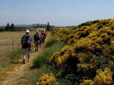
The village is crossed by the Chemin de Regordane (GR700), an almost unique communication axis connecting the Massif Central to the Mediterranean, which was heavily used during the Middle Ages. Originally, this path was known as l’Estrade (from Occitan estrada, meaning “great road,” derived from Latin strata). In the 12th century, at the request of the Bishop of Mende, the village became a border post defended by a garrison responsible for the safety of travelers and goods along the Regordane. Throughout the 13th century, this place was simply called La Garde.
 The name Guerin only appears in 1298. The fortified village, or castrum de La Garde, is co-owned by a community of knights known as los Pariers (in Occitan: “the Equals,” from Latin pares). This community had both economic and military functions, following the spirit of flourishing chivalric schools in France since the 12th century. These knights swore an oath to the Bishop of Mende. Each parier owned a parerie, also called a part or portion, for which they assumed responsibility and collected revenues. These responsibilities included toll collection, grain measurement rights (cartelage), guiding and protecting travelers, animals, and goods along the portion of the Chemin de Regordane they maintained, as well as the right to collect dust (pulverage) raised by herds of animals.
The population of the village has varied significantly over the centuries. In 1789, there were over 100 inhabitants, while in 1846, there were 158, and by 1936, it had decreased to 84. Today, around a dozen residents live there year-round, but during the summer period, the population increases to about a hundred people.
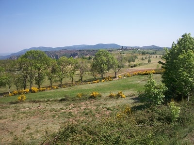
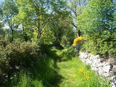
Regarding the natural environment of La Garde-Guerin, the village is situated within the Cevennes National Park, a mountainous region in southern France. This area is renowned for its spectacular landscapes, rivers, and gorges, as well as its diverse and rich flora and fauna. Common plant species in the region include holm oak, downy oak, chestnut, beech, Scots pine, juniper, thyme, lavender, heather, foxglove, martagon lily, and lady’s slipper orchid, among others.
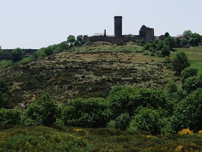
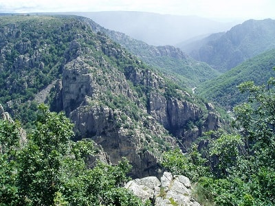
This fortified village, isolated on a plateau, overlooks the rugged rocks of the Chassezac gorge. In the 12th century, at the request of the Bishop of Mende, it was established to protect travelers using the GR®700 Voie Regordane, the sole communication route between Auvergne and Roussillon. Twenty-seven nobles, known as the “pariers”, settled here.
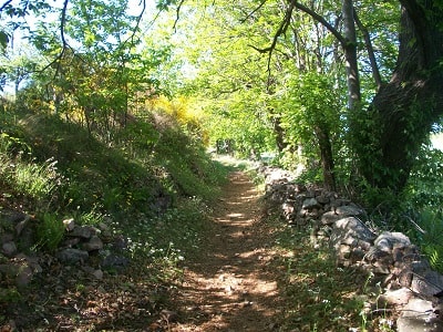
All their houses were perfectly identical. With its strong castle and most of its ramparts, the village, closed to automobile traffic, has preserved its appearance from that era. Today, most of the former homes of the pariers serve as sheepfolds for the village’s few inhabitants. About 1 kilometer to the north, a trail branching off from the old D906 road leads in five minutes to the dizzying Chassezac viewpoint, which overlooks the chaotic gorge below, where the torrent roars
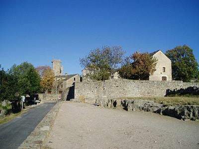
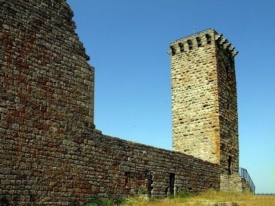
 La Garde-Guerin, a well-known stopover village along the GR®700 Voie Regordane, is now a particularly attractive tourist site. On-site, the high watchtower, once surrounded by ramparts, still displays beautiful remnants. The restored castle and village form a remarkably homogeneous medieval ensemble. In the past, it was the domain of the “chevaliers pariers”, a highly original military association—a sort of policing militia—that protected and guided travelers along the Regordane. At one point, there were up to thirty of these knights, adhering to meticulous and precise statutes, managing responsibilities and income distribution.
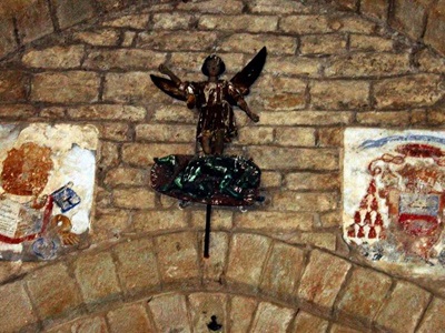
 The donjon (keep) stands 27 meters tall. Its floors have vaulted ceilings. Without stairs, they were connected by narrow ladders and hatches. The village’s church, formerly the chapel of the “château,” has been well-restored and is considered a Romanesque architectural gem. At the top of the triumphal arch, a polychrome Saint Michael defeats a horned devil. The village boasts beautiful capitals, and many of its old houses have been restored. Visitors can admire splendid gateways and ancient staircases. For a warm welcome, head to the Nogier brothers’ Auberge Regordane, a Logis de France hotel-restaurant.
In 1965, La Garde-Guerin was an almost abandoned village, struggling to sustain a few farmers. However, it possessed a rich architectural heritage that needed preservation. It was possible to restore this unique village, recreating an economic and social way of life. Thanks to the Direction de l’Architecture in Paris, La Garde-Guerin was chosen as a pilot village and received significant subsidies.
The creation of an inn in the village’s most beautiful house, the restoration of the historically classified church, street and rampart improvements, and water supply works were undertaken in 1966 and lasted several years. 25 years later, what was once a gamble became a reality: the inhabitants remained in the village, while others settled permanently or for vacations after the restoration of most of the previously abandoned houses.
Now, the concerted efforts of the residents within an association ensure the continuity of this endeavor. La Garde-Guerin has become a popular destination for thousands of tourists. The respect for the environment and the enhancement of the architectural heritage have restored its identity and vitality. It stands as a testament to a rich past passed down to humanity, illuminating a different dimension and emphasizing the importance of the environment as a necessary component of balance and lifestyle. The beauty of these places bears witness to this transformation!
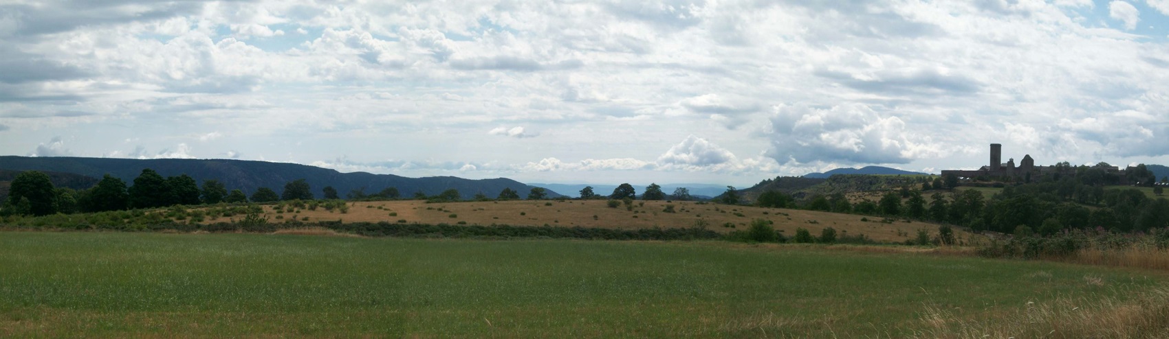
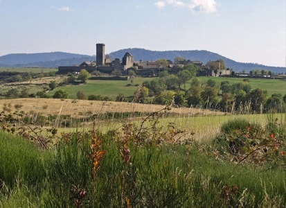
La Garde-Guerin, a medieval fortified village, is remarkably situated near the GR®700 Voie Regordane and perched above the Gorges du Chassezac, commanding a height of 400 meters.
 From a distance, travelers can spot the village, nestled at an altitude of nearly 900 meters, on a sandstone plateau often swept by winds. The base of the plateau consists of granite rocks, within which the Chassezac torrent has carved impressive gorges. The village enjoys an exceptional location, dominating the surrounding landscape. To be convinced, one need only visit the Pre de la Tour or the belvedere des Gorges du Chassezac. Even today, one can see everything around without obstruction. Moreover, the site is traversed by the GR®700 Voie Regordane, which has played a significant role throughout history.
This natural communication route runs from north to south along the eastern face of the Cevennes. It connected Montpellier and Nîmes to Le Puy en Velay (the starting point for the Chemins de St Jacques GR®65, the GR®700 Voie Regordane, or the Chemin de St Gilles, and the Chemin de Stevenson GR®70), and extended to Clermont Ferrand. It passed through Ales, Portes, Chamborigaud, Genolhac (circling Mont-Lozere on the GR®68), Villefort, and continued toward La Garde-Guerin, Prevencheres, Le Thort, La Bastide Puylaurent, Luc, and Langogne.
 This site bears the remnants of a robust human settlement dating back to the Neolithic period. How could the ancient Regordane path not be dotted with more or less fortified stations? La Garde-Guerin was an ideal place to establish a cap barre, which means a fortified station with wooden palisades rather than stones.
Later, the Gauls must have built an oppidum or stronghold. Unfortunately, we know little about that era. What we can say is that the Regordane path was a pre-Roman transhumance route.
Before Julius Caesar’s conquest of Gaul in 52 BCE, the Celtic tribe known as the Gabales inhabited the territory of present-day Lozere. They participated in the struggle for Gaul’s independence alongside Vercingetorix and the Arverni tribe, to whom they were “clients.” They owed them respect, loyalty, certain services, and military assistance.
Interestingly, the Gabales sustained themselves through agriculture and livestock. They used the GR®700 Voie Regordane both for transhumance and as a trade route for wine and other products from the Cevennes, some of which were already sold in Nîmes, including cheeses
 Pline the naturalist, who died in the 1st century AD during the eruption of Mount Vesuvius, said that the most appreciated cheese in Rome was from Mont Lozere and the Cevennes. The Gallo-Romans continued to use this route. It is known that instead of adhering to the principle of a straight line, Roman roads often followed the twists and turns of earlier Gaulish itineraries. They traveled with chariots, and a relay system along the road allowed them to transport goods from the Mediterranean to Lozere. In fact, oyster shells have been found during excavations at various archaeological sites. In certain places, such as the Estrade de Saint-Andre de Cap-Ceze, the ruts left by chariot wheels can be clearly seen. These ruts are spaced 1.42 meters apart, similar to those found in Pompeii. At Coudoulous, on a spur of the Regordane, which headed west toward Mende, you can even see in the rock the trace of the “sabots” that allowed chariot drivers, struggling uphill, to hold the chariot in place.
 A privileged site
Local powers organized themselves around certain privileged sites, and La Garde-Guerin was one of them, thanks to its position on a well-traveled communication axis. The lords were well aware of this and, perhaps as early as the 11th century, established people to guard the road and ensure the safety of travelers and goods. They likely swiftly built a castle with a watchtower, possibly even in the 11th century. The current village owes the first part of its name to the existence of this structure, from which one could survey the entire horizon.
In the Dictionnaire etymologique des noms de lieux en France (Etymological Dictionary of Place Names in France), we learn that the word “Garde” comes from the Germanic “Wart” and means guard, watchtower, or fortress. Many villages and towns in France share the name “La Garde”: La Garde Freinet, La Garde Adhemar, and it has been observed that they are all built on elevated, strategic sites. For example, in La Garde Freinet, a Saracen fortress was constructed in the 9th century. The term “place forte” (stronghold) was often associated with La Garde. In a text written in Latin during the 12th century, we find: “castrum quod vocatur la Garda,” the strong place called La Garde. The exact time when “Guerin” was added to the name La Garde remains uncertain. Generally, it is believed that the lords who settled in La Garde around the 12th century bore the name Guerin. “Guerin” is a common surname associated with the three baronies of Randon, d’Apcher, and du Tournel. The existence of the Guerin family is documented in a donation to the Abbey of Gellone, now known as Saint-Guilhem-du-Desert, dating back to 1054.
It was a Guerin du Tournel who took charge of this castle and became its suzerain. The Tournel was indeed firmly established in Villefort and also possessed La Garde. The Lords of Tournel were masters of Mont Lozere and part of Sauveterre. They held garrisons at strategic points and soon turned their attention to this unique penetration route connecting the Midi to the Massif Central. The Rhône’s banks, a well-guarded border throughout history, were not the chosen path. When the name La Garde was augmented with Guerin, was it not a tribute to these powerful lords, the Guerin du Tournel? The G.A.R.D.E Association is based in La Garde-Guerin, 48800 Villefort
***
 The Secret of La Garde-Guerin Dungeon
Once upon a time, in the heart of the 12th century, there existed a small village perched on a rocky plateau, surrounded by thick forests and deep gorges. This village was La Garde-Guerin. Its stone houses lined the winding alleys, and atop the hill stood an imposing dungeon. The dungeon, 27 meters high, symbolized the power of the parier knights, nobles who had sworn to protect travelers along the Voie Regordane. Yet behind its thick walls lay a mystery, a secret jealously guarded by the village elders.
One winter evening, as snow covered the rooftops, a young shepherd named Gaspard discovered a hidden trapdoor beneath an old tree stump. Intrigued, he descended into the depths of the dungeon, guided by the flickering light of a torch.
 There, in a vaulted room, he found a carved wooden chest. Inside rested a parchment yellowed with age. Gaspard deciphered the ancient characters and discovered the village’s history. He learned that the parier knights were not only guardians of the road but also guardians of a legendary treasure. This treasure, hidden somewhere in the dungeon’s underground passages, consisted of precious objects, jewels, and most importantly, a mysterious elixir capable of curing all illnesses.
Gaspard decided to share his discovery with the other villagers. Together, they explored the secret passages of the dungeon, braving the traps and riddles left by the ancient knights. They found secret chambers filled with riches, but the elixir remained elusive.
Over the years, the village prospered thanks to this hidden treasure. The inhabitants lived in harmony, healed of their ailments, and the legend of La Garde-Guerin spread throughout the region. But one day, a stranger arrived in the village. He called himself Lorenzo, and his eyes gleamed with a greedy light. Having heard of the treasure, he was willing to do anything to seize it. Lorenzo infiltrated the dungeon, solving the puzzles with diabolical skill. Finally, he reached the chamber where the elixir lay. Yet as he touched it, a mysterious force threw him backward, leaving him unconscious on the stone floor. When Lorenzo regained consciousness, he was changed. His greed had vanished, replaced by genuine compassion for the villagers. He decided to protect the treasure rather than steal it. Since that day, La Garde-Guerin has become a place of healing for all who seek the legendary elixir. And the dungeon’s secret remains well-guarded, passed down from generation to generation.
Old romantic Hotel, L'Etoile Guest-House is a mountain retreat in the South of France. With a beautiful park along the Allier River, L'Etoile Guesthouse is located in La Bastide-Puylaurent between Lozere, Ardeche and Cevennes. Many hiking trails like GR®7, GR®70 Stevenson trail, GR®72, GR®700 Regordane way, Cevenol, GR®470 Allier river, Margeride. Many hiking loops. The right place to relax.
Copyright©gr-infos.com